Photo by Photo Submitted
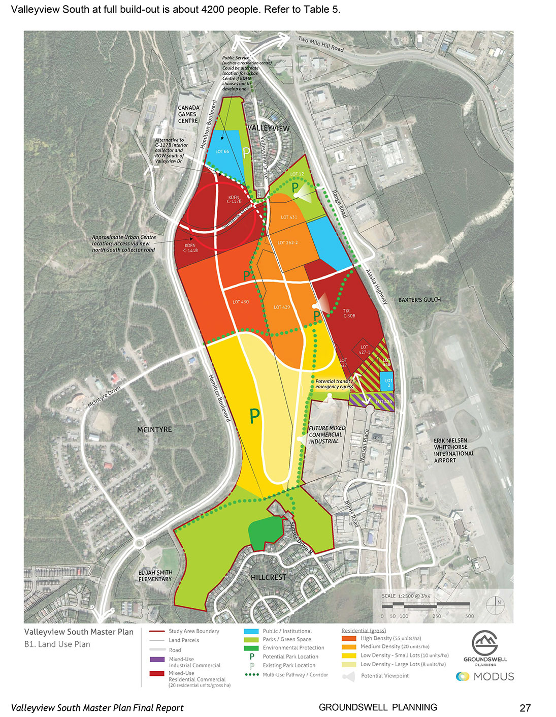
SHADES OF A GROWING CITY – At full build-out over approximately the next 15 years, Valleyview South, also known as the tank farm area, would provide homes for some 4,200 people. Map courtesy GROUNDSWELL PLANNING
Photo by Photo Submitted
SHADES OF A GROWING CITY – At full build-out over approximately the next 15 years, Valleyview South, also known as the tank farm area, would provide homes for some 4,200 people. Map courtesy GROUNDSWELL PLANNING
The proposed “master plan” for the new Valleyview South neighbourhood – the old upper tank farm lands, as some know the area – is ready for public scrutiny.
The proposed “master plan” for the new Valleyview South neighbourhood – the old upper tank farm lands, as some know the area – is ready for public scrutiny.
City council was briefed on the plan Monday evening, with formal approval expected at its March 25 meeting.
A public input session on the draft final master plan is scheduled for April 22 in council chambers.
“The master plan is meant to be high-level, it lists possible uses for this site, but (specific uses) would be determined when general rezoning for the entire site is done,” senior planner Karmen Whitbread told council.
So if the city wanted to signal that recreation infrastructure would be best built across the road from the Canada Games Centre (CGC), it wouldn’t need to be in the master plan, he said.
Coun. Ted Laking said he would prefer something more explicit in the master plan, however.
“It’s important to leverage the location, next to the CGC, Mount Mac, and the highway,” he said.
The 116-hectare brownfield site could accommodate up to 3,500 new dwelling units, according to the 220-page master plan.
Development would be in phases over the next 15 years, with significant grading in places, new roads, and a mix of community amenities.
The plan is available online at the engagewhitehorse.ca website.
It’s not yet clear how much it will cost to develop the area.
“Developers pay for development,” Whitbread noted, although the city may have to pay for studies involving the land it owns.
At a minimum, about 4,000 people will live in the neighbourhood.
The plan calls for 27.3 ha of greenspace, including five neighbourhood parks and a buffer around the new neighbourhood.
There will be a mix of densities, ranging from eight to 55 units per gross hectare.
A mixed-use urban centre, with higher-density land uses, would be centred around the Hamilton Boulevard/Sumanik Drive intersection .
The northwest corner of the neighbourhood would likely be developed first, as it is the flattest.
It could take up to 15 years to level out the steeper portions of the site, according to the landowners, Whitbread said.
Work on the master plan began in late 2022, with input gathered from 684 people along with information from the 2018 Transit Plan, 2018 Bicycle Network Plan, 2020 Trail Plan, and Kwanlin Dün First Nation and Ta’an Kwäch’än Council documents.
The 16 land parcels are owned by the private sector, the KDFN, the TKC, the Yukon government or the city.
The only developments in the area right now are a place of worship (Gurdwara Akaljot Sahib) and several satellite dishes.
The Valleyview subdivision lies to the north, the McIntyre subdivision across Hamilton Boulevard to the west and Hillcrest to the south.
During the Second World War, 24 large tanks were built on the site to store gasoline, furnace oil and arctic stove oil that had been brought by pipeline from Skagway, for use by the military.
The tank farm stopped operating in 1995 and the tanks removed in 1997.
It took years to remediate the site, and even now, a few portions are still designated as contaminated.
The master plan will help accommodate the growth of Whitehorse’s population and the needs of future residents. It is intended to:
ensure the new development will fit in with existing neighbourhoods;
integrate the area with existing infrastructure, such as roads and water/sanitary systems; and
identify major future roads and active transportation corridors.
The Valleyview South master plan contains two key components: land use concept maps and a detailed report.
The report provides guidance on land use (land use compatibility and environmental impacts), density, land remediation, gravel hauling, on and off-site infrastructure, and financial feasibility.
In order to encourage thoughtful and responsible discussion, website comments will not be visible until a moderator approves them. Please add comments judiciously and refrain from maligning any individual or institution. Read about our user comment and privacy policies.
Your name and email address are required before your comment is posted. Otherwise, your comment will not be posted.
Be the first to comment