Photo by Vince Fedoroff
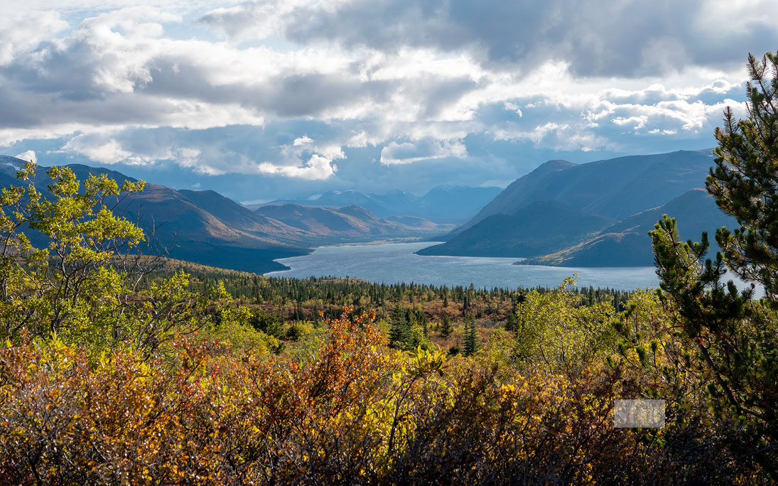
PLANNING PROCESS TO BEGIN – The Fish Lake area, seen from Mt. McIntyre in September 2020, will be the subject of an extensive planning exercise over the next several years, it was announced Thursday.
Photo by Vince Fedoroff
PLANNING PROCESS TO BEGIN – The Fish Lake area, seen from Mt. McIntyre in September 2020, will be the subject of an extensive planning exercise over the next several years, it was announced Thursday.
The Yukon government and Kwanlin Dün First Nation (KDFN) are launching a local area planning process for the Łu Zil Män (Fish Lake) area.
The Yukon government and Kwanlin Dün First Nation (KDFN) are launching a local area planning process for the Łu Zil Män (Fish Lake) area.
A local area plan will identify public land and KDFN settlement lands for residential use, traditional use and community development.
A local area planning process can take a few years to be completed.
The KDFN said Thursday this will help citizens reconnect to their ancestral home at Fish Lake.
This process is initiated under Section 30 of KDFN’s Self-Government Agreement, where two governments signed a memorandum of understanding in March 2020 to develop a local area plan for the area.
The planning process involves consultation with all members of the community and other stakeholders.
A steering committee engages with the public, stakeholders and First Nations citizens, and gathers feedback for consideration.
A consultant is working on a background report that will help guide the development of the local area plan.
The steering committee, comprised of representatives from both governments, will co-ordinate and develop the recommendations for the co-operative plan.
“The local area planning process is invaluable in guiding land development and reducing land use conflicts in an area,” the government said.
“The process provides local residents and those with strong ties to the area with the opportunity to influence the decisions about land use and ensures broad public interests are taken into consideration.”
“Given the proximity of Łu Zil Män (Fish Lake) to Whitehorse, its popularity as a recreational and tourism area, and its importance to Kwanlin Dün First Nation and Ta’an Kwächän Council, this local area planning process will be of high interest to many,” said Energy, Mines and Resources Minister Ranj Pillai.
“We look forward to working co-operatively with Kwanlin Dün First Nation, Ta’an Kwächän Council and the community on developing a local area plan for this beautiful and popular area.”
This is the first local area planning process initiated under the KDFN’s new Lands Act, Nan kay sháwthän Däk'anúta ch'e (We look after our land), which came into force in October 2020.
“Łu Zil Män (Fish Lake) has always been an important site to the people of Kwanlin Dün First Nation,” said Chief Doris Bill.
“Our ancestors have used the land and water for sustenance for many thousands of years. Our strong connection to the site continues today.
“As we embark on this process in partnership with the Government of Yukon, we look forward to building a plan that will honour the traditional uses of the area and balance our modern uses with conservation of the land, water and wildlife, and with the treaty rights of KDFN citizens.
“It signifies another step forward in our First Nation’s self-determination,” Bill added.
Interested parties can submit expressions of interest to be part of the steering committee with the territorial government until Feb. 15.
The Fish Lake area, west of Whitehorse, is approximately 460 square kilometres.
Current land use includes a mixture of rural residential, agricultural, commercial, recreational, and subsistence activities.
The lake is located in KDFN traditional territory, and the Ta’an Kwächän Council has a site specific parcel in the planning area.
It’s named for the round whitefish that spawn there in the fall.
First Nations families and their ancestors have fished, trapped, hunted and gathered in the Fish Lake area for millennia – and continue to do so today.
The KDFN has a large amount of settlement lands in the Fish Lake valley, though the entire area is known to be important to First Nations people.
Archeological digs in the area show evidence of human occupation dating from historic times to the end of the last Ice Age.
The largest site was a traditional fish camp on the north end of the lake.
The types of tools found at this site show people have been using it for at least 5,000 to 8,000 years. More than 40 other archaeological sites are known to exist in the area and additional sites are very likely.
A local plan designates areas for specific land uses. It also defines a community’s vision for the future and guides the development and use of land in unincorporated Yukon communities.
Where possible, the government and First Nations whose traditional territory includes the planning area work in partnership.
The steering committee will comprise residents of the local area with an equal representation of nominees from the government and First Nations.
The committee will:
• work with planning staff from each government to develop terms of reference for the planning contract;
• select a planning consultant who will facilitate the development of the plan;
• review background analysis (prepared by planning consultant);
• develop a vision for the community;
• present plan options;
• develop a preferred plan; and
• recommend the plan for approval.
The planning process involves the steering committee consulting with all members of the community and other stakeholders.
Any recommended plan under the process is reviewed and approved by the government. If it has been prepared jointly with a First Nation, it’s reviewed and approved by chief and councils.
Local area plans are implemented through area development regulations, also known as zoning.
Local area plans are reviewed every five to 10 years to ensure they reflect changing conditions and values in a community.
They may be amended from time to time to reflect changing land use demands or economic conditions. Plan amendments are subject to public consultation.
Yukoners can get involved in a local area planning process by attending public meetings, completing surveys and by providing input and suggestions to the steering committee.
In order to encourage thoughtful and responsible discussion, website comments will not be visible until a moderator approves them. Please add comments judiciously and refrain from maligning any individual or institution. Read about our user comment and privacy policies.
Your name and email address are required before your comment is posted. Otherwise, your comment will not be posted.
Comments (2)
Up 6 Down 3
Groucho d'North on Jan 17, 2021 at 3:10 pm
@What
I believe you are refering to the time when the land claims land freeze got lifted and many went looking for available land and made applications for the area outside City limits West of the Copper Haul Road.
Up 7 Down 7
What, no comments? on Jan 15, 2021 at 11:45 pm
Remember when the Yukon Con Party allowed a land rush on the Fish Lake area back in 2004? (and of course it didn't go through, shady dealings, no consultation with anybody). Strangely no body is mentioning that. Glad to see consultation with all stakeholders is taking place. Beautiful area valued by FN and Yukoners.